
Notes about NAV2T ship display
Overview of NAV2T
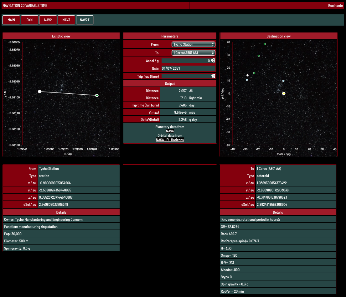
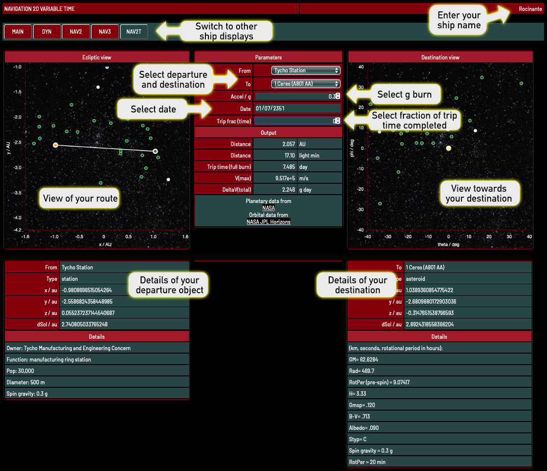
NAV2T enables you to set the date and then determine the distances between key places in the solar system. It also displays information about the start and finish objects and displays the view towards the destination.
You can switch back and forth between it and the other ship displays. The trip parameters are passed between the displays using the URL (see URL params for details).
You can also use these parameters to create links that set up NAV2T in the right configuration for you.
Going from Ceres to Neputune on the Pella, using data for 2355-06-02, and a 0.1 g burn? Try this:
https://www.iandrea.co.uk/sf/displays/code/nav2t.html?&from=15,1%20Ceres%20(A801%20AA)&to=11,Neptune&name=Pella&accel=0.1&date=2355-06-02
The easiest way to work out these URLs is to set up the details in NAV2T, then switch to DYN and back again.
Locations included
Key places include:
*These moons are included for compatibility with the other ship displays. NAV2T assumes they are at the same position as their parent planet.
- Sol
- The eight planets
- Three moons: Luna, Phobos, Deimos*
- Pluto
- Asteroids 1 to 100 (1 Ceres to 100 Hekate)
- Asteroids 243 Ida, 433 Eros, 532 Herculina, 951 Gaspra
- Comets Tempel 1, Wild2, and Borelly
- 90377 Sedna
- Tycho Station and Anderson Station from The Expanse
*These moons are included for compatibility with the other ship displays. NAV2T assumes they are at the same position as their parent planet.
Location data
NAV2T uses data from the superb JPL Horizons system.
It uses orbital elements for 2351-07-01 and then calculates the positions for a given date. Details of how this can be done are given on https://ssd.jpl.nasa.gov/planets/approx_pos.html.
I only consider time-variation of the anomaly, not of other orbital parameters.
These positions will be approximate, with the errors increasing the more the data differs from 2351-07-01. Errors will be less for planets with near circular orbits than for asteroids with eccentric ones.
All positions of planets are for the barycentre (the centre of mass of the planet and its moons). These are more accurate than planetary positions for dates in the far future, such as these.
I do not attempt to calculate the positions of moons, instead giving them the same position as their parent. NAV2T displays a warning if you try to do this. I have included the moons so that you can switch between NAV2T and the other ship displays without generating errors.
I suggest you use NAV2 if you need to calculate approximate trip times between planets and their moons.
If you want to most accurate positions, do not use NAV2T. Instead use JPL Horizons system to get the vector positions for the two objects (at the time of interest). You can then calculate the distance between them (SQRT((x1 - x0)^2 + (y1 - y0)^2 + (z1 - z0)^2) and put that value into DYN.
Station locations
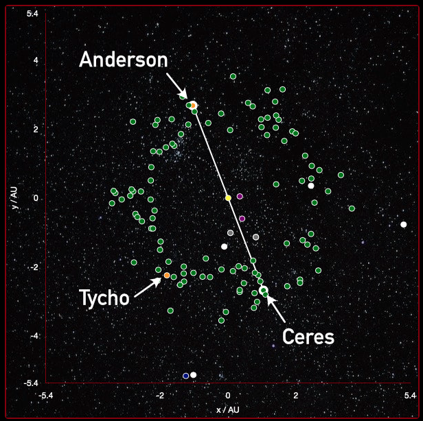
I put Anderson Station and Tycho Station on the same orbit as Ceres, with Tycho at a L4/L5 Ceres lagrange point, and Anderson opposite Ceres (at L3).
Note that Anderson will not be always directly opposite Ceres as the orbit they follow is elliptical.
Note that Anderson will not be always directly opposite Ceres as the orbit they follow is elliptical.
Journey plotting
Several simplifications are made when plotting journeys.
I assume that the journey times are short compared with orbital periods and that the journey can be plotted using the positions of the start and finish objects at the time of the journey start. Otherwise the calculations become much more complicated.
The journey time assumes constant burn (with a half-way flip). No coast. Switch to DYN If you want to investigate the effect to journey times of adding a coast.
Checking the positions
Use the JPL Horizons system if you want to check the locations of NAV2T.
Please contact me if you spot any errors or bugs, or if you have suggestions for improvement.
Please contact me if you spot any errors or bugs, or if you have suggestions for improvement.